New Film: Citizen Jane: Battle for the City
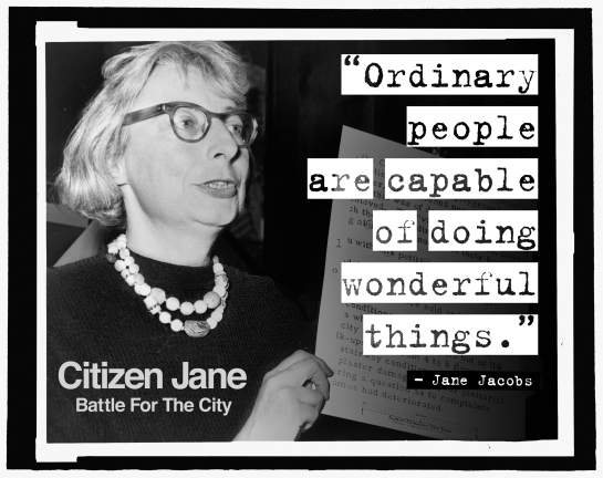
In 1960 Jane Jacobs’ book The Death and Life of Great American Cities sent shockwaves through the architecture and planning worlds, with its exploration of the consequences of modern planners’ and architects’ reconfiguration of cities. Jacobs was also an activist, who was involved in fights in mid-century New York to stop ‘master builder’ Robert Moses from running roughshod over the city. This film retraces the battles for the city as personified by Jacobs and Moses, as urbanization moves to the very front of the global agenda. Many of the clues for formulating solutions to the dizzying array of urban issues can be found in Jacobs’ prescient text, and a close second look at her thinking and writing about cities is very much in order. This film sets out to examine the city of today though the lens of one of its greatest champions.
DIRECTOR’S STATEMENT
In the face of developers and the overzealous parks commissioner Robert Moses, who, in
the 1950s, wanted to run a four-lane highway through the middle of the park, Jacobs and
other Greenwich Village residents and activists organized a formal opposition to the city’s plans.
Through community-driven support, a large neighborhood coalition, a series of public protests, and a years-long letter-writing campaign to officials at every level of city government, Jacobs and her compatriots eventually triumphed and Moses’s park-destroying plan was shelved.
It was a battle much like the one Sanders’s campaign has framed today: a grassroots coalition of regular people fed up with the top-down impositions of the powers that be running roughshod over regular citizens.
Jacobs, whose centenary will be celebrated on May 4, is something of a spiritual soul mate to Sanders. The parallels between their underlying ideologies are striking. And as
Sanders’s popularity and fame continues to skyrocket, it’s time to give his fellow New
Yorker, Jacobs, her due. Jacobs’s fight for Washington Square Park—and for the people’s right to the city—is a story I tell in Citizen Jane (which is produced by one of New
York’s newer grassroots activists, High Line co-founder Robert Hammond).
Like the modern-day opposition to the role of big banks and the political influence of the wealthiest one percent, Jane Jacobs and the Greenwich Village community members were fighting against a power structure that valued its own perseverance over the public it was ostensibly serving. She, more than anyone else of her era, deserves credit for unmasking this unseemly cabal.
A BATTLE FOUGHT IN THE STREETS
Citizen Jane: Battle for the City is a story about our global urban future, in which nearly three-fourths of the world’s population will live in cities by the end of this century. It’s also a story about America’s recent urban past, in which bureaucratic, “top down” approaches to building cities have dramatically clashed with grassroots, “bottom up” approaches. The film brings us back mid-century, on the eve of the battles for the heart and soul of American cities, about to be routed by cataclysmically destructive Urban Renewal and highway projects.
The film details the revolutionary thinking of Jane Jacobs, and the origins of her magisterial 1961 treatise The Death and Life of Great American Cities, in which she single-handedly undercuts her era’s orthodox model of city planning, exemplified by the massive Urban Renewal projects of New York’s “Master Builder,” Robert Moses. Jacobs and Moses figure centrally in our story as archetypes of the “bottom up” and the “top down” vision for cities. They also figure as two larger-than-life personalities: Jacobs—a journalist with provincial origins, no formal training in city planning, and scarce institutional authority—seems at first glance to share little in common with Robert Moses, the upper class, high prince of government and urban theory fully ensconced in New York’s halls of power and privilege.
Yet both reveal themselves to be master tacticians who, in the middle of the 20th century, became locked in an epic struggle over the fate of the city. In three suspenseful acts,
Citizen Jane: Battle for the City gives audiences a front row seat to this battle, and shows how two opposing visions of urban greatness continue to ripple across the world stage, with unexpectedly high stakes, made even higher and more unexpectedly urgent in the suddenly shifting national political landscape of 2017, in which the newly inaugurated U.S. President is a real estate developer, who is calling for a new era Urban Renewal, echoing the traumatic period in which this film takes place. In perilous times for the city and for civil rights, Citizen Jane offers a playbook, courtesy of Jane Jacobs, for organizing communities and speaking the truth to entrenched and seemingly insurmountable powers.


