Archive

British Colonial Architecture

Field Work: Axim and Dixcove

Heading west from Takoradi along the coast-road towards Côte d’Ivoire there are a number of fishing towns and natural harbours, such as Axim and Dixcote.

img_0697

Dixcove Harbour

IMG_0692.jpg

Fishing Boats at Dixcove

Axim was a major port during the early 20thC, exporting £250,000 worth of goods in 1913, and the mail boat from Liverpool (as well as ships from the US, Germany and Belgium) called every 10-15 days before heading on to Sekondi. Before the British occupied the Fort at Axim (Fort St. Anthony) it was held built by the Portuguese in 1515 and then captured by the Dutch from 1642. The Fort was conceded to Britain, along with the other Dutch forts east of Elmina on the 6th April 1872.

A European hospital was established in the town in 1901, and the British Bank of West Africa opened a branch, having traded in Accra from 1897. There are still some colonial buildings to be found, and a photograph of the District Commissioner’s bungalow (c.1914) is held in the UK National Archives.
axim-bungalow

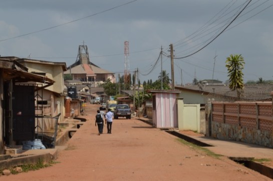
Type B Public Works Department Bungalow in Axim

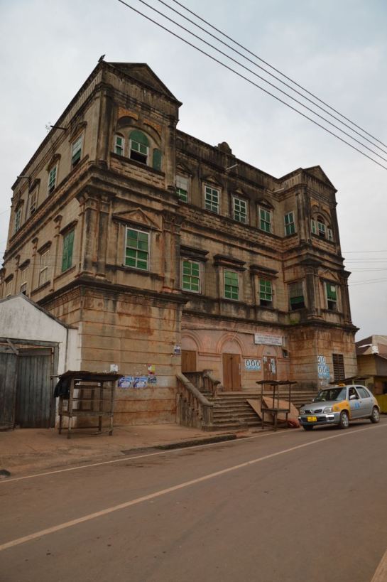
Besides the Fort, the Quandahor Building dominates the town from its elevated position. The building (according to some sources) was built in the 1920s, but with what purpose and by whom?

dsc_0426

Quandahor Building in Axim

Nearby Dixcove also has its fort (macabrely named Fort Metal Cross after the slave branding iron used there) and the town still retains its thriving fishing industry. The fortress was constructed from 1683 by the Royal African Company and continues to resemble the 1806 print below. Needless to say, it is a harrowing structure, and a surviving relic of what must be one of the lowest points of British history.  By 1868 the Fort was under Dutch control, before being returned to the British just four years later. It was made a World Heritage Site in 1979 and has recently been inhabited by an Englishman intent on refurbishing the place.

phpthumb_generated_thumbnailjpg-2

1806 Print depicting Dixcove

DSC_0414.jpg

Dixcove Fortress

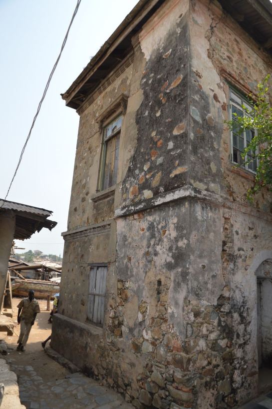
It was only in 1911 that a Customs Warehouse was completed and a market shed was erected in the Dixcove – is the image below the customs warehouse? A few other Colonial period buildings survive and we will endeavour to find out more about this fascinating place.

dsc_0423

The Customs Warehouse in Dixcove?

An Update from Takoradi, Ghana Part 2

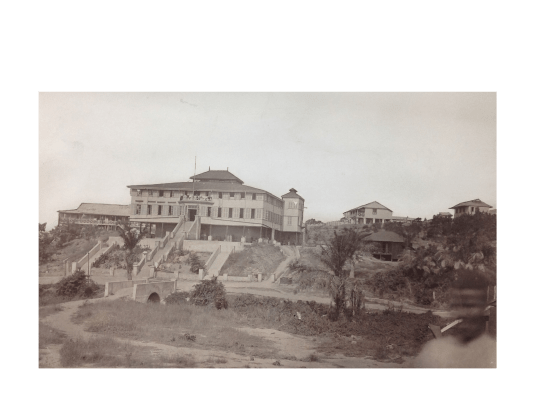
The docks and rail infrastructure of Takoradi was the impetus behind its rapid expansion from a small village to a major town. Construction commenced after WW1, but before this took place, it was neighbouring Sekondi that dominated the area with its grand houses, trading offices and the plush Metropole Hotel. The Dutch established Fort Orange there from 1670 and the natural harbour provided a suitable place for light vessels to shelter whilst the surf boats manned by the Kru people brought goods and people ashore.

evernote-snapshot-20160720-121210-copy

The Metropole Hotel, Sekondi

There is some rich architectural heritage in this town, and clear evidence of a once prospering settlement full of traders and merchants. Those days are clearly gone.

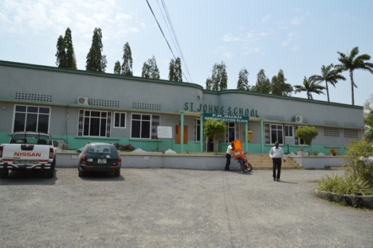
We started with two schools, the first called Fijai, captured here by the UK National Archives Africa through a lens. Then onto St. John’s, again the vintage photo below shows the clean lines of the school, when constructed c. 1955.


dsc_0383

St. John’s School, Sekondi

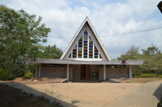
There have been further additions to the school including the striking church, donated by a Wisconsin family , with its large A-line structural frame,  finely detailed concrete casting, wooden ceiling and pre-cast screening. Next to St. John’s is Adiembra housing estate. There were revisions proposed for Adiembra in the 1944 Town Planning report made by Maxwell Fry and Jane Drew, but it is difficult to ascertain what impact this report made on the area, if any. However, we did spot some standpipes and washing stations that resemble those proposed by Fry and Drew in their manual, Village Housing in the Tropics, so perhaps this is evidence of their involvement.

dsc_0376

The Church at St. John’s School

We went onto the main street of Sekondi where the Post Office is located. We discussed this building in our chapter in Bremner’s Architecture and Urbanism in the British Empire, but were now shocked to see how the exquisite timber counter had been painted in bright blue gloss – destroying the previous display of tropical hardwoods. The rest of the street has only gotten worse since our last visit, with many of the former colonial buildings on the brink of collapse. Absent landlords coupled with a shrinking economy has left these structures vulnerable and economically unviable. Further sad news must be reported, as the modernist Sekondi Regional Library has recently been demolished and replaced with a new library.

Our final visit in Sekondi was to the coastal-road village of Ekuasie, laid out in 1912. This was an early attempt at providing worker housing and adopts the familiar grid iron street format, although far more loosely imposed than similar schemes elsewhere (such as Korle Gono). There are some later and grander additions to this village, including a set of houses from the mid 1950s.

img_0663

Ekuasie Housing Estate

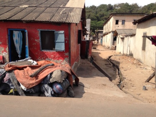
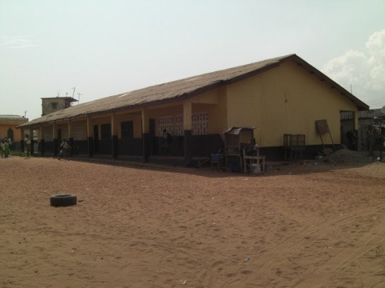
We returned to Takoradi and explored the workers’ estate, mentioned in the PRAAD archives as the ‘labourers housing and school’ at the Zongo area. This is still a thriving area, Hausa was heard being spoken and the tiny streets eventually lead to a playground-cum-village square, overlooked by the Islamic school and Mosque.

cimg5294

Takoradi Zongo School

An Update from Takoradi, Ghana

We started at the Takoradi Train Station, completed by 1928 as part of the coastal rail and docklands development. The train lines were initially constructed to transport cash crops, minerals and metals from the northern agricultural and mining districts to the awaiting ships, sheltered in the newly constructed breakwater and deep water harbour. When we visited in 2012 the train station was completely derelict and not in use. Today we found it carefully restored and new tracks laid. The plan is to reuse it for a local transport network. We walked up the hill to the small commercial district made up of international banks and a post and telegrams office. The mishmash of styles reveals the incremental development, as well as the fierce competition between the banks eager to differentiate themselves from the competition.

The former European hospital clock tower up on the hill overlooks the banks and docklands, as well as benefiting from the cooling sea breeze.

We drove to the 1920s part of Takoradi, a major new town extension that was built to accompany the docks development of that time. This portion of the town was primarily for the African population, although it also contains the Lasdun designed Bank of Ghana [built 1957]. Lasdun was also the architect of the National Museum in Accra. The bank was vacant when we visited in 2012, but now it stands in a state of complete dereliction, its fine materials and fixings being stripped from the building. This is a real tragedy. It was once an outstanding building, recorded in the Architecture journals of the day and surely one of Lasdun’s greatest works from this period.

img_0633

Somewhat downbeat, we bid farewell to the bank, and made our way to the rond-point in the middle of the town. The map was deceiving, as this was built as a major market place – our driver told us it was one of the largest markets in West Africa. It had the feel of Kariakoo market  in Dar es Salaam, and also contains a delightful little PWD post office with its signage graphics still intact.

Adjacent to the market is Amanful Village. Laid out in 1922-3 it is a mixed use area of housing and commercial properties. The basic PWD-type houses and layout remained in place, but more wealthy owners had transformed much of the upper part of the estate to suburban housing.

We then went to the Takoradi Technical Institute, shown above (Left, b+w) in the Africa Through a Lens Collection at the UK National Archives. There is a forcefulness to this scheme that takes the familiar two storey gallery access format, and emboldens into more ‘clunky’ yet determined architectural-structural forms.

dsc_0363

Nearby is the Effiekuma housing and the Effia Nkwanta hospital. The hospital has evolved overtime from a European hospital-cum-sanatorium in the colonial period, to a major health provider today. The careful layering and response to the site contours offers delightful views as well as a most welcome breeze to all the small structures that each have a view of the docks. At the top of the hill is a large brutalist extension that dates from c. late 1960s early 1970s. But who designed it?

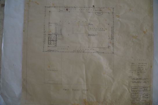
As part of our British Academy Internationalisation and Mobility grant Iain Jackson and Ola Uduku visited Rexford Opong at KNUST in March (we included some brief updates here: Notes from Kumasi and Notes from Kumasi: part 2 and also Notes from Kumasi Part 3). We were fortunate enough to visit the Estate Planning Department and drawing offices and photographed some of the original drawings made of the university estate and buildings. Whilst every effort is being made to carefully preserve these drawings they have been subject to the ravages of time, humidity and vermin attack and many are in a poor state of repair. They are unlikely to survive for much longer.

dsc_0170

Drawing of the First Floor Senior Staff Club House, KNUST

In an attempt to remedy and counter this we are putting together an ‘Archives in Danger’ grant that, if successful, will enable these important artefacts to be digitally scanned/carefully photographed and then carefully preserved and archived for future scholarship.

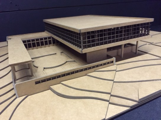
In the meantime we’ve used the photographed drawings to produce a series of new CAD files. Pedro Bittencourt, a student based at Liverpool School of Architecture, has worked dilligently on translating the imperial scales into a metric format and has produced all of the new drawings. He has then used these drawings to construct a beautiful scale model of the Club House, utilising a laser cutter as to form the delicate components.

pedro

Pedro with the completed scale model

We’re hoping to produce additional models of other buildings on campus that can be used in exhibitions and as part of our lecture series.

img_0125img_0126

The Architecture of Edwin Maxwell Fry and Jane Drew:

We’re delighted to announce that our Fry and Drew book is to be published in paperback format in a few days time. This should make it a little more affordable and hopefully accessible to a broader audience in West Africa and India…

9781409451983

https://www.routledge.com/The-Architecture-of-Edwin-Maxwell-Fry-and-Jane-Drew-Twentieth-Century/Jackson-Holland/p/book/9781409451983


Architect-entrepreneurs in post-independence Pune (India)

Sarah Melsens, Priyanka Mangaonkar-Vaiude, Yashoda Joshi
Department of Architectural Engineering, Vrije Universiteit Brussel (VUB), BelgiumDepartment of Architecture, BRICK school of Architecture, Pune, India

Abstract

With the purpose of expanding the built infrastructure in their colonial empire the British imparted technical training to Indians since the mid nineteenth century. These construction related courses initially focussed on assistant, supervisory and executive tasks but evolved into the training of civil engineers. Half a century later, in 1913, a handful of British architects in Bombay took the initiative to develop an existing drafting school for architectural assistants into India’s first school of architecture. Through such schools, and the gradual employment of Indians at higher ranks in Indo-British firms or the Public Works Department (PWD), Indian architects and engineers acquired British methods of working and construction. While construction practice during the British Raj (1858-1947) has gained scholarly attention recently, less is known of how construction was practiced after India’s independence in 1947. Analysis of the profiles of professional firms has shown to be a fruitful means of gaining insight in the workings of the construction field. In order to understand how construction practice was carried forward, this paper will therefore study the first Indian architect-entrepreneurs, who established their firms after Independence.

Architecture graduates from JJ School of Art

Architecture Graduates from J. J. School of Art formed the nationwide Indian Institute of Architects in 1929. Top Left: G. B. Mhatre, and Bottom second from Left: C. M. Master with council members of the Indian Institute of Architects, Bombay, 1936-1937

The study is built on data collected from interviews and office archives of three Indian architectural and entrepreneurial offices, which were based in Pune and active in the period 1947-1982. The paper analyses the type of projects these firms were working on, the procedures and organisation of design and construction, and the prevailing construction techniques of the period. As such this contribution will shed light on how, in a post-colonial situation, western models of construction practice were translated into the Indian context.

keywords

Construction practice, architects, post-independence, India, Pune

You may read the rest of this fascinating article here: TNAGblog_architectenterpreneurspune

2016 Grantees for Conserving Modern Architecture Initiative Announced

TAG is delighted that the Getty Foundation has awarded a ‘Keeping it Modern’ heritage grant to the Children’s Library in Accra, Ghana – the first time this prestigious award has been made to a building in Africa. This will fund building research into the material fabric of the library, as well as programme of events to keep the space activated and enjoyed.

The library was designed by Nickson and Borys (see Notes from Accra ) in late 1950s / early 1960s (the building appears in J. M. Richard’s New Buildings of the Commonwealth, 1961) and has already received some sympathetic restoration in more recent times, as well as some less fortunate interventions (such as the aluminium front door).

The latest project will be in safe hands under the leadership of the ArkiAfrica team, http://archiafrika.org/wp-content/uploads/2013/03/march-13-invite.jpg  and we will post updates on the project here.

Getty press release and information on the other awards here: http://blogs.getty.edu/iris/2016-grantees-for-conserving-modern-architecture-initiative-announced/


Oxford University Press will publish ‘Architecture and Urbanism in the British Empire’ on 7th October 2016. Below is a brief synopsis from the publishers website.

9780198713326

Throughout today’s postcolonial world, buildings, monuments, parks, streets, avenues, entire cities even, remain as witness to Britain’s once impressive if troubled imperial past. These structures are a conspicuous and near inescapable reminder of that past, and therefore, the built heritage of Britain’s former colonial empire is a fundamental part of how we negotiate our postcolonial identities, often lying at the heart of social tension and debate over how that identity is best represented.

This volume provides an overview of the architectural and urban transformations that took place across the British Empire between the seventeenth and mid-twentieth centuries. Although much research has been carried out on architecture and urban planning in Britain’s empire in recent decades, no single, comprehensive reference source exists. The essays compiled here remedy this deficiency. With its extensive chronological and regional coverage by leading scholars in the field, this volume will quickly become a seminal text for those who study, teach, and research the relationship between empire and the built environment in the British context. It provides an up-to-date account of past and current historiographical approaches toward the study of British imperial and colonial architecture and urbanism, and will prove equally useful to those who study architecture and urbanism in other European imperial and transnational contexts.

The volume is divided in two main sections. The first section deals with overarching thematic issues, including building typologies, major genres and periods of activity, networks of expertise and the transmission of ideas, the intersection between planning and politics, as well as the architectural impact of empire on Britain itself. The second section builds on the first by discussing these themes in relation to specific geographical regions, teasing out the variations and continuities observable in context, both practical and theoretical.

Table of Contents:

Introduction
Architecture, Urbanism, and British Imperial Studies, G. A. Bremner
PART I: Themes in British Imperial and Colonial Architecture and Urbanism
1: Beginnings: Early Colonial Architecture, Daniel Maudlin
2: Urbanism and Master Planning: Configuring the Colonial City, Robert Home and Anthony D. King
3: Stones of Empire: Monuments, Memorials, and Manifest Authority, G. A. Bremner
4: The Metropolis: Imperial Buildings and Landscapes in Britain, G. A. Bremner
5: Propagating Ideas and Institutions: Religious and Educational Architecture, G. A. Bremner and Louis P. Nelson
6: Imperial Modernism, Mark Crinson
Part II Regional Continuity, Divergence, and Variation in the British World
7: British North America and the West Indies, Harold Kalman and Louis P. Nelson
8: South and Southeast Asia, Preeti Chopra
9: The Australian Colonies, Stuart King and Julie Willis
10: New Zealand and the Pacific, Ian Lochhead and Paul Walker
11: Sub-Saharan Africa, Iain Jackson and Ola Uduku
12: Egypt and Mandatory Palestine and Iraq, Samuel D. Albert

Further details here: https://global.oup.com/academic/product/architecture-and-urbanism-in-the-british-empire-9780198713326?cc=ro&lang=en&# 

cleoroberts's avatarEnvisioning the Indian City

Announcement

Four-year PhD Studentships

Location: University of Westminster

Deadline: 26th August 2016

Two x four-year, full time PhD studentships in the Faculty of Architecture and the Built Environment as part of ERC grant funded project Monsoon Assemblages.

Stipend of £16,000 p.a. and Tuition Fees (Home/EU fees only).

Full article

Two x four-year, full time PhD studentships

Monsoon Assemblages is a five-year long research project funded by the European Research Council (Starting Grant no. 679873) with the ambition of confronting challenges of urban climate change through novel, inter-disciplinary research in three of South Asia’s rapidly growing cities: Chennai, Delhi and Dhaka. It is driven by questions of how these cities might be transformed if no longer thought of as exclusive products of human agency, but as co-designed by the material energies of earth systems.

PhD applications are invited from the spatial design and/or environmental humanities disciplines to engage with these questions. The exact areas of…

View original post 119 more words

An update on the Architecture and cultural heritage between the Ganges and Gibraltar Symposium by Cleo Roberts.

cleoroberts's avatarEnvisioning the Indian City

Settled Topographies: From Gibraltar to the Ganges

ArCHIAM Centre Conference

July 11 – 12, 2016

10:00 – 17:00

School of the Arts Library

19 Abercromby Square

Liverpool

Last week the ArCHIAM Centre at Liverpool School of Architecture hosted a two day symposium, ‘Settled Topographies: From Gibraltar to the Ganges’, exploring how culture and spatiality have comingled across this trans-continental region in contemporary and historical settings. As Professor Souymen Bandyopadhyay (Director ArCHIAM) introductory remarks stated, ‘there is a need to reflect on the area’s global interactions to help inform contributions to the present world’.

The opening sessions including papers by Dr Iain Jackson (University of Liverpool), ‘State Building and Nation Creation: British Mandate Architecture and Planning in Iraq’, and Cleo Roberts, ‘The River Ganges: Colonial Calcutta’s Sub-City’, provided a rich insight into how British colonial relationships had sought to harness inherited environments through a combination of infrastructural, and prestige projects, and…

View original post 982 more words